Earthquakes
USGS
| MAG | UTC DATE-TIME y/m/d h:m:s |
LAT deg |
LON deg |
DEPTH km |
Region | |
|---|---|---|---|---|---|---|
| MAP | 4.2 | 2012/10/09 22:51:19 | -43.470 | 172.780 | 9.0 | SOUTH ISLAND OF NEW ZEALAND |
| MAP | 2.7 | 2012/10/09 22:22:38 | 53.543 | -166.035 | 48.8 | FOX ISLANDS, ALEUTIAN ISLANDS, ALASKA |
| MAP | 4.8 | 2012/10/09 22:14:23 | -59.790 | -26.637 | 99.1 | SOUTH SANDWICH ISLANDS REGION |
| MAP | 2.5 | 2012/10/09 21:01:35 | 63.001 | -150.385 | 119.3 | CENTRAL ALASKA |
| MAP | 3.4 | 2012/10/09 20:56:13 | 18.760 | -65.142 | 50.0 | VIRGIN ISLANDS REGION |
| MAP | 2.9 | 2012/10/09 19:18:45 | 18.376 | -64.438 | 101.0 | VIRGIN ISLANDS REGION |
| MAP | 4.7 | 2012/10/09 18:34:51 | -4.475 | 129.245 | 52.0 | BANDA SEA |
| MAP | 2.9 | 2012/10/09 17:24:37 | 58.717 | -153.623 | 13.0 | KODIAK ISLAND REGION, ALASKA |
| MAP | 3.8 | 2012/10/09 17:21:40 | 19.493 | -64.377 | 64.0 | VIRGIN ISLANDS REGION |
| MAP | 4.3 | 2012/10/09 16:11:58 | 20.759 | 122.184 | 158.2 | BATAN ISLANDS REGION, PHILIPPINES |
| MAP | 3.7 | 2012/10/09 16:06:50 | 19.627 | -64.324 | 54.0 | VIRGIN ISLANDS REGION |
| MAP | 4.0 | 2012/10/09 15:50:55 | 24.438 | -109.398 | 10.0 | GULF OF CALIFORNIA |
| MAP | 3.5 | 2012/10/09 15:21:30 | 19.566 | -64.429 | 52.0 | VIRGIN ISLANDS REGION |
| MAP | 2.5 | 2012/10/09 13:03:32 | 62.862 | -150.833 | 109.5 | CENTRAL ALASKA |
| MAP | 3.4 | 2012/10/09 13:00:02 | 33.711 | -117.343 | 9.2 | SOUTHERN CALIFORNIA |
| MAP | 6.4 | 2012/10/09 12:32:04 | -61.033 | 153.960 | 10.2 | BALLENY ISLANDS REGION |
| MAP | 4.5 | 2012/10/09 12:14:29 | -23.428 | -179.854 | 596.6 | SOUTH OF THE FIJI ISLANDS |
| MAP | 2.6 | 2012/10/09 11:24:56 | 60.114 | -153.183 | 126.6 | SOUTHERN ALASKA |
| MAP | 3.0 | 2012/10/09 08:49:10 | 35.777 | -97.163 | 5.0 | OKLAHOMA |
| MAP | 4.8 | 2012/10/09 07:57:52 | -2.692 | 139.200 | 45.9 | NEAR THE NORTH COAST OF PAPUA, INDONESIA |
| MAP | 5.5 | 2012/10/09 07:49:54 | -2.757 | 139.179 | 36.9 | NEAR THE NORTH COAST OF PAPUA, INDONESIA |
| MAP | 5.2 | 2012/10/09 07:14:59 | -2.710 | 139.088 | 33.3 | NEAR THE NORTH COAST OF PAPUA, INDONESIA |
| MAP | 3.4 | 2012/10/09 04:55:44 | 62.780 | -149.622 | 70.1 | CENTRAL ALASKA |
| MAP | 4.6 | 2012/10/09 04:41:59 | 4.856 | 96.543 | 54.2 | NORTHERN SUMATRA, INDONESIA |
| MAP | 4.7 | 2012/10/09 03:30:35 | -29.413 | -69.348 | 111.4 | SAN JUAN, ARGENTINA |
| MAP | 2.6 | 2012/10/09 03:00:53 | 47.103 | -121.113 | 1.5 | WASHINGTON |
| MAP | 4.8 | 2012/10/09 00:30:21 | -20.896 | -174.074 | 27.7 | TONGA |
| MAP | 2.6 | 2012/10/09 00:11:32 | 18.950 | -66.373 | 40.0 | PUERTO RICO REGION |
…………………………..
Seismic movement in Hunza: Landslides affect 15 families, damage infrastructure

A view of the mountains affected by tremors in Mayoon and Hussainabad villages of Hunza-Nagar District. PHOTO: SHABBIR MIR/THE EXPRESS TRIBUNE
The landslides damaged a main water channel and other public and private property in Mayoon and Hussainabad villages.
“At least 15 families have moved in with their relatives in view of the looming threat,” Shahzad Hussain, a resident of the area told The Express Tribune on Monday. He said that the landslides started two weeks ago.
So far a main water channel, a link road and 12 electricity polls have been damaged. The landslides have also destroyed wild fruit trees.
“There is no light or no water in the area,” Hussain said, adding that the remaining villagers are also considering moving due to the tremors. Complaints to officials over the disrupted water and electricity supply yielded no result.
Another resident said fissures have already appeared in the ground in some parts. He said the villagers who had moved away did so on the advice of experts sent by a non-governmental organisation.
Another villager said, “We hope the government will act swiftly to minimise our losses.”
Others were not as hopeful, saying that past landslides have devastated several houses, orchards and standing crops in Shinaki area, but the government did not do anything for the people.
Gilgit-Baltistan Disaster Management Authority Director Burhan Afandi said that the government is planning to conduct a survey in the area to find the cause behind landslides and tremors.
“Thirteen families have been relocated as a precautionary measure and we will be conducting a survey to find out the causes,” he said.
In 2010, the government had shifted 55 families from Hussainabad village to safer places due to landslides, but later the villages returned as the situation turned back to normal. According to the then Hunza deputy commissioner, fissures had developed on some parts of the surface, causing landslide in the region, which is on a fault line.
Published in The Express Tribune
Deformation of Earth’s crust to south of Baku can lead to serious quakes and narrowing of Caspian

Baku, Fineko/abc.az. American seismologist predicts an increase in seismic activity of Baku and on the Absheron peninsula.
At the International Seismology Conference taking place in Baku American scientist and seismologist Robert King has informed that in Baku and Absheron peninsula it is expected an increase in seismic activity as a result of compression fracture between the Minor and the Greater Caucasus.
“Our research showed that the Arabian and Eurasian lithospheric plate is characterized by high strength, and as a result they do not deform internally, and tremors are the result of oceanic activity, located between these territories. In the entire Caucasus a fault is observed, in the south and the north there is some movement and deformation in the lowlands between the Minor and the Greater Caucasus. In the Baku seismic zone the speed of fault is 12 mm a year over 100 km. At that, to the south of Baku it is observed fracture and displacement of the Earth’s crust in the direction of the Caspian Sea, where compression takes place that will lead to a narrowing of the Caspian Sea. At the same time, we find it difficult to predict the results of all the occurring processes,” he said.
According to Mr. King, in order to predict the results of the occurring processes it is needed to determine whether a similar contraction is in the depths of the earth, develop a range of different geodetic models, neotectonics, a map of faults that will be possible as the installation of 25 new seismic stations.
“To continue the research, stations should be installed at a distance of 5-10 km from each other on the perimeter of the fault. It is necessary to invest in this as much money as has already been invested in the purchase and installation of stations in order to study the processes occurring in the soil, as well as raising of the level of oil reservoirs. All these studies are important in order to determine possible effects of very large deformations that occur to the south of Baku, in order to prepare for a possible earthquake,” he said.
No tsunami threat from southwestern Pacific quake
A preliminary 6.4-magnitude earthquake struck 452 miles northwest of the Balleny Islands region early this morning at 2:32 a.m., but presented no tsunami threat to Hawaii, according to the Pacific Tsunami Warning Center.
The earthquake struck at a depth of about 6.3 miles.
The Balleny Islands are a series of uninhabited volcanic islands that are part of Antarctica.
LISS – Live Internet Seismic Server
GSN Stations
These data update automatically every 30 minutes. Last update: October 10, 2012 06:49:11 UTC
Seismograms may take several moments to load. Click on a plot to see larger image.
CU/ANWB, Willy Bob, Antigua and Barbuda

CU/BBGH, Gun Hill, Barbados

CU/BCIP, Isla Barro Colorado, Panama

CU/GRGR, Grenville, Grenada

CU/GRTK, Grand Turk, Turks and Caicos Islands

CU/GTBY, Guantanamo Bay, Cuba

CU/MTDJ, Mount Denham, Jamaica

CU/SDDR, Presa de Sabaneta, Dominican Republic

CU/TGUH, Tegucigalpa, Honduras

IC/BJT, Baijiatuan, Beijing, China

IC/ENH, Enshi, China

IC/HIA, Hailar, Neimenggu Province, China

IC/LSA, Lhasa, China

IC/MDJ, Mudanjiang, China

IC/QIZ, Qiongzhong, Guangduong Province, China

IU/ADK, Aleutian Islands, Alaska, USA

IU/AFI, Afiamalu, Samoa

IU/ANMO, Albuquerque, New Mexico, USA

IU/ANTO, Ankara, Turkey

IU/BBSR, Bermuda

IU/BILL, Bilibino, Russia

IU/CASY, Casey, Antarctica

IU/CCM, Cathedral Cave, Missouri, USA

IU/CHTO, Chiang Mai, Thailand

IU/COLA, College Outpost, Alaska, USA

IU/COR, Corvallis, Oregon, USA

IU/CTAO, Charters Towers, Australia

IU/DAV,Davao, Philippines

IU/DWPF,Disney Wilderness Preserve, Florida, USA

IU/FUNA,Funafuti, Tuvalu

IU/FURI, Mt. Furi, Ethiopia

IU/GNI, Garni, Armenia

IU/GRFO, Grafenberg, Germany

IU/GUMO, Guam, Mariana Islands

IU/HKT, Hockley, Texas, USA

IU/HNR, Honiara, Solomon Islands

IU/HRV, Adam Dziewonski Observatory (Oak Ridge), Massachusetts, USA

IU/INCN, Inchon, Republic of Korea

IU/JOHN, Johnston Island, Pacific Ocean

IU/KBS, Ny-Alesund, Spitzbergen, Norway

IU/KEV, Kevo, Finland

IU/KIEV, Kiev, Ukraine

IU/KIP, Kipapa, Hawaii, USA

IU/KMBO, Kilima Mbogo, Kenya

IU/KNTN, Kanton Island, Kiribati

IU/KONO, Kongsberg, Norway

IU/KOWA, Kowa, Mali

IU/LCO, Las Campanas Astronomical Observatory, Chile

IU/LSZ, Lusaka, Zambia

IU/LVC, Limon Verde, Chile

IU/MA2, Magadan, Russia

IU/MAJO, Matsushiro, Japan

IU/MAKZ,Makanchi, Kazakhstan

IU/MBWA, Marble Bar, Western Australia

IU/MIDW, Midway Island, Pacific Ocean, USA

IU/MSKU, Masuku, Gabon

IU/NWAO, Narrogin, Australia

IU/OTAV, Otavalo, Equador

IU/PAB, San Pablo, Spain

IU/PAYG Puerto Ayora, Galapagos Islands

IU/PET, Petropavlovsk, Russia

IU/PMG, Port Moresby, Papua New Guinea

IU/PMSA, Palmer Station, Antarctica

IU/POHA, Pohakaloa, Hawaii

IU/PTCN, Pitcairn Island, South Pacific

IU/PTGA, Pitinga, Brazil

IU/QSPA, South Pole, Antarctica

IU/RAO, Raoul, Kermandec Islands

IU/RAR, Rarotonga, Cook Islands

IU/RCBR, Riachuelo, Brazil

IU/RSSD, Black Hills, South Dakota, USA

IU/SAML, Samuel, Brazil

IU/SBA, Scott Base, Antarctica

IU/SDV, Santo Domingo, Venezuela

IU/SFJD, Sondre Stromfjord, Greenland

IU/SJG, San Juan, Puerto Rico

IU/SLBS, Sierra la Laguna Baja California Sur, Mexico

IU/SNZO, South Karori, New Zealand

IU/SSPA, Standing Stone, Pennsylvania USA

IU/TARA, Tarawa Island, Republic of Kiribati

IU/TATO, Taipei, Taiwan

IU/TEIG, Tepich, Yucatan, Mexico

IU/TIXI, Tiksi, Russia

IU/TRIS, Tristan da Cunha, Atlantic Ocean

IU/TRQA, Tornquist, Argentina

IU/TSUM, Tsumeb, Namibia

IU/TUC, Tucson, Arizona

IU/ULN, Ulaanbaatar, Mongolia

IU/WAKE, Wake Island, Pacific Ocean

IU/WCI, Wyandotte Cave, Indiana, USA

IU/WVT, Waverly, Tennessee, USA

IU/XMAS, Kiritimati Island, Republic of Kiribati

IU/YAK, Yakutsk, Russia

IU/YSS, Yuzhno Sakhalinsk, Russia

***********************************************************************************************************
Extreme Temperatures/ Weather
| 09.10.2012 | Forest / Wild Fire | Bulgaria | Sofia-Capital, [Vitosha Mountain] |  |
 |
Forest / Wild Fire in Bulgaria on Tuesday, 09 October, 2012 at 12:55 (12:55 PM) UTC.
| Description | |
| A large wildfire has erupted Tuesday around noon on the Vitosha Mountain just outside Bulgaria’s capital Sofia. Firefighters have been alerted by citizens about a blaze in the Mecha Polyana (Bear’s Glade) area between the Aleko center and the Bistrishko Branishte reserve in the mountain. The billowing smoke, fanned by high winds, is clearly visited from Sofia, which is located on Vitosha’s northern foothills. Bulgaria’s firefigthing service has reported that the blaze is hard to tackle due to the terrain and windy conditions. 70 firefighters and foresters have been sent to the location, which currently encompasses some 2.5 acres of alpine grassland and pine forest. |
***********************************************************************************************************
Storms / Flooding
| Active tropical storm system(s) | ||||||||||
| Name of storm system | Location | Formed | Last update | Last category | Course | Wind Speed | Gust | Wave | Source | Details |
| Prapiroon (22W) | Pacific Ocean | 08.10.2012 | 10.10.2012 | Typhoon III | 295 ° | 157 km/h | 194 km/h | 4.57 m | JTWC | |
Tropical Storm data
|
|||||||||||||||||||||||||||||||||||||||||||||||||||||||||||||||||||||||||||||||||||||||||||||||||||||||||||||||||||||||||||||||||||||||||||||||
|
|||||||||||||||||||||||||||||||||||||||||||||||||||||||||||||||||||||||||||||||||||||||||||||||||||||||||||||||||||||||||||||||||||||||||||||||
| Today | Flash Flood | Russia [Asia] | Republic of Dagestan, [Derbent City region] |  |
|
Flash Flood in Russia [Asia] on Wednesday, 10 October, 2012 at 06:39 (06:39 AM) UTC.
| Description | |
| Heavy rains caused flooding that killed seven people in the southern Russian province of Dagestan on Wednesday, the Emergency Situations Ministry said. About 320 homes in the Caspian Sea coastal city of Derbent close to the Caucasus Mountains were flooded and seven bodies were found, the ministry said. In Derbent, warnings were issued from loudspeakers at mosques and mounted on cars dispatched around the city in the mostly Muslim province, Ekho Moskvy radio reported. |
************************************************************************************************************
Epidemic Hazards / Diseases
| Today | Epidemic | Puerto Rico | [Statewide] | |
|
Epidemic in Puerto Rico on Wednesday, 10 October, 2012 at 03:12 (03:12 AM) UTC.
| Description | |
| Puerto Rico’s health department has declared a dengue epidemic. Health Secretary Lorenzo Gonzalez says at least six people have died, including two children younger than 10. A total of 4,816 cases have been reported, including 21 cases of the potentially fatal hemorrhagic dengue. The U.S. Centers for Disease Control and Prevention says 342 new cases were reported in one week last month, twice the number of cases during the same period last year. Dengue cases usually flare up from August to January. The mosquito-borne virus causes fever, severe headaches and extreme joint and muscle pain. Dengue claimed a record 31 lives during a 2010 epidemic that saw more than 12,000 suspected cases. Gonzalez made the announcement on Monday. | |
| Biohazard name: | Dengue Fever |
| Biohazard level: | 3/4 Hight |
| Biohazard desc.: | Bacteria and viruses that can cause severe to fatal disease in humans, but for which vaccines or other treatments exist, such as anthrax, West Nile virus, Venezuelan equine encephalitis, SARS virus, variola virus (smallpox), tuberculosis, typhus, Rift Valley fever, Rocky Mountain spotted fever, yellow fever, and malaria. Among parasites Plasmodium falciparum, which causes Malaria, and Trypanosoma cruzi, which causes trypanosomiasis, also come under this level. |
| Symptoms: | |
| Status: | confirmed |
************************************************************************************************************
Climate Change
Vast differences in Antarctic and Arctic polar ocean microbial communities reported


Read more at: http://phys.org/news/2012-10-vast-differences-antarctic-arctic-polar.html#jCp
Journal reference: Proceedings of the National Academy of Sciences 
Provided by University of Michigan
************************************************************************************************************
Solar Activity
3MIN News October 9. 2012
Published on Oct 9, 2012 by Suspicious0bservers
Pole Shift Video: http://youtu.be/uI10tKuLtFU
STARWATER: http://youtu.be/LiC-92YgZvQ
TODAY’S LINKS
SpaceX Fail: http://cosmiclog.nbcnews.com/_news/2012/10/08/14297705-spacex-launch-problems…
Polar Biodiversity: http://phys.org/news/2012-10-vast-differences-antarctic-arctic-polar.html
REPEAT LINKS
Spaceweather: http://spaceweather.com/ [Look on the left at the X-ray Flux and Solar Wind Speed/Density]
HAARP: http://www.haarp.alaska.edu/haarp/data.html [Click online data, and have a little fun]
CERES JPL: http://ssd.jpl.nasa.gov/sbdb.cgi?sstr=ceres;orb=1;cov=0;log=0;cad=0#orb
SDO: http://sdo.gsfc.nasa.gov/data/ [Place to find Solar Images and Videos - as seen from earth]
SOHO: http://sohodata.nascom.nasa.gov/cgi-bin/soho_movie_theater [SOHO; Lasco and EIT - as seen from earth]
Stereo: http://stereo.gsfc.nasa.gov/cgi-bin/images [Stereo; Cor, EUVI, HI - as seen from the side]
SunAEON:http://www.sunaeon.com/#/solarsystem/ [Just click it... trust me]
SOLARIMG: http://solarimg.org/artis/ [All purpose data viewing site]
iSWA: http://iswa.gsfc.nasa.gov/iswa/iSWA.html [Free Application; for advanced sun watchers]
NASA ENLIL SPIRAL: http://iswa.gsfc.nasa.gov:8080/IswaSystemWebApp/iSWACygnetStreamer?timestamp=…
NOAA ENLIL SPIRAL: http://www.swpc.noaa.gov/wsa-enlil/
US Wind Map: http://hint.fm/wind/
NOAA Bouys: http://www.ndbc.noaa.gov/
NOAA Environmental Visualization Laboratory: http://www.nnvl.noaa.gov/Default.php
RSOE: http://hisz.rsoe.hu/alertmap/index2.php [That cool alert map I use]
GOES Xray: http://www.swpc.noaa.gov/sxi/goes15/index.html
JAPAN Radiation Map: http://jciv.iidj.net/map/
LISS: http://earthquake.usgs.gov/monitoring/operations/heliplots_gsn.php
Gamma Ray Bursts: http://grb.sonoma.edu/ [Really? You can't figure out what this one is for?]
BARTOL Cosmic Rays: http://neutronm.bartol.udel.edu//spaceweather/welcome.html [Top left box, look for BIG blue circles]
TORCON: http://www.weather.com/news/tornado-torcon-index [Tornado Forecast for the day]
GOES Weather: http://rsd.gsfc.nasa.gov/goes/ [Clouds over America]
RAIN RECORDS: http://www.cocorahs.org/ViewData/ListIntensePrecipReports.aspx
EL DORADO WORLD WEATHER MAP: http://www.eldoradocountyweather.com/satellite/ssec/world/world-composite-ir-…
PRESSURE MAP: http://www.woweather.com/cgi-bin/expertcharts?LANG=us&MENU=0000000000&…
HURRICANE TRACKER: http://www.weather.com/weather/hurricanecentral/tracker
INTELLICAST: http://www.intellicast.com/ [Weather site used by many youtubers]
NASA News: http://science.nasa.gov/science-news/science-at-nasa/
PHYSORG: http://phys.org/ [GREAT News Site!]
QUAKES LIST FULL: http://www.emsc-csem.org/Earthquake/seismologist.php
ACTIVE SUNSPOT:
A sunspot, currently located on the farside of the sun, is about to emerge over the sun’s southeastern limb. It is crackling with M-class solar flares and could bring a significant uptick in solar activity.
************************************************************************************************************
Space
Earth approaching objects (objects that are known in the next 30 days) |
|||||||||
| Object Name | Apporach Date | Left | AU Distance | LD Distance | Estimated Diameter* | Relative Velocity | |||
| (1994 EK) | 14th October 2012 | 4 day(s) | 0.1356 | 52.8 | 230 m – 520 m | 12.22 km/s | 43992 km/h | ||
| (2012 PA20) | 15th October 2012 | 5 day(s) | 0.1502 | 58.5 | 100 m – 230 m | 10.36 km/s | 37296 km/h | ||
| (2012 RV16) | 18th October 2012 | 8 day(s) | 0.1270 | 49.4 | 310 m – 700 m | 16.14 km/s | 58104 km/h | ||
| 214869 (2007 PA8) | 05th November 2012 | 26 day(s) | 0.0433 | 16.8 | 1.5 km – 3.3 km | 10.79 km/s | 38844 km/h | ||
| (2011 UG21) | 06th November 2012 | 27 day(s) | 0.1784 | 69.4 | 340 m – 760 m | 19.73 km/s | 71028 km/h | ||
| (2010 WT) | 07th November 2012 | 28 day(s) | 0.1251 | 48.7 | 53 m – 120 m | 6.53 km/s | 23508 km/h | ||
|
|||||||||
DRAGON AND THE ISS:
Laden with supplies, SpaceX’s Dragon spacecraft is approaching the International Space Station for docking on Wednesday, Oct. 10th. Last night, David Blanchard saw the commercial spacecraft chasing the ISS across the sky above Flagstaff, Arizona:
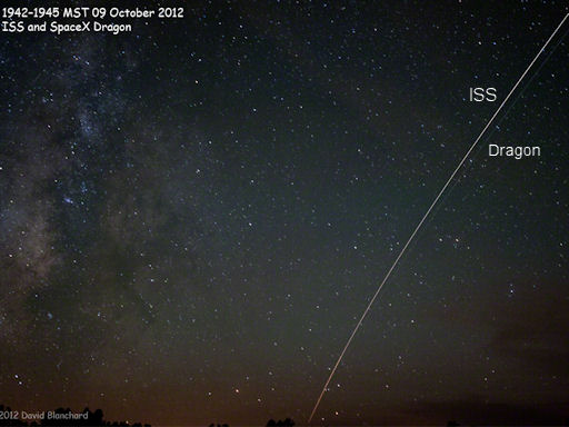
“The Dragon capsule raced to catch the ISS as the pair moved across the western sky separated by about 20 seconds,” says Blanhard. “This image is a single 30-s exposure that shows the separation and how Dragon trails ISS.”
On Wednesday, these two streaks will merge. As the Dragon approaches the ISS, astronaut and station commander Suni Williams will reach out with the station’s robot arm to grapple the capsule. The spacecraft will then be joined to one of the station’s ports where astronauts will unload its 1,000 pounds of food, clothing, science gear and other items. Later, the astronauts will load almost 2,000 pounds of used equipment and experiments into the Dragon to be returned to Earth safely in about three weeks.
GEOMAGNETIC ACTIVITY CONTINUES:
For the third day in a row, geomagnetic storms are circling the poles. In North America, auroras have spilled across the Canadian border descending as far south as Utah, Colorado, Kansas, and Nebraska. The best place to see the show, according to pilot Matt Melnyk, is from the window of an airplane:
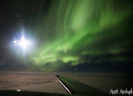
“I photographed an unbelievable display from the cockpit at 21,000 feet while flying across Alberta Canada,” says Melnyk. “Being the pilot we get a front row view of the amazing aurora and this display was nothing less than spectacular!”
The storms were instigated by a CME strike on Oct. 8th and they are about to be re-energized by a solar wind stream due to hit Earth’s magnetic field on Oct. 10th. NOAA forecasters estimate a 40% chance of strong geomagnetic storms during the next 24 hours, so high-latitude sky watchers should remain alert for auroras
*************************************************************************************************************
Biological Hazards / Wildlife / Hazmat
Biological Hazard in South Africa on Tuesday, 09 October, 2012 at 09:55 (09:55 AM) UTC.
| Description | |
| A large section of coastline in South Africa has been closed after a 30-metre whale washed ashore following an attack by Great White sharks. The whale was removed from the surf after its carcass attracted high numbers of Great Whites to the coast by Muizenberg beach, near Cape Town, on Sunday. Authorities have since taken the southern right whale from the beach but have closed off a stretch of shore from Muizenberg to Monwabisi ‘as a precaution’. Disaster response teams had moved swiftly to get the animal out of the water and onto a flat-bed truck. Wilfred Solomons-Johannes, a spokesman for Cape Town’s disaster risk management centre, said: ‘A decision was taken to begin the recovery operation immediately because of the increase of shark activity off beaches along the False Bay coastline.’ The warning did not stop curious onlookers streaming to the site. Claire McKinnon, manager of the Cape Town cleansing and solid-waste management department, said samples were taken from the carcass to enable pathologists to establish the cause of death before it was disposed of at a landfill site. Once the whale was out of the water, a bulldozer rolled it over the sand. Solomons-Johannes said it was not known whether the whale was alive when the sharks attacked it or had succumbed to an illness. ‘Under normal circumstances predators such as sharks often sneak up on their prey from behind or underneath. Predators don’t usually face off in a fight,’ he said. ‘A predator goes in quickly and quietly attacks the prey. Predators choose the ill, injured, young or old animals to hunt because they are easier to catch.’ | |
| Biohazard name: | Shark Attack (Great White Shark) |
| Biohazard level: | 1/4 Low |
| Biohazard desc.: | Bacteria and viruses including Bacillus subtilis, canine hepatitis, Escherichia coli, varicella (chicken pox), as well as some cell cultures and non-infectious bacteria. At this level precautions against the biohazardous materials in question are minimal, most likely involving gloves and some sort of facial protection. Usually, contaminated materials are left in open (but separately indicated) waste receptacles. Decontamination procedures for this level are similar in most respects to modern precautions against everyday viruses (i.e.: washing one’s hands with anti-bacterial soap, washing all exposed surfaces of the lab with disinfectants, etc). In a lab environment, all materials used for cell and/or bacteria cultures are decontaminated via autoclave. |
| Symptoms: | |
| Status: | confirmed |
| 09.10.2012 | Biological Hazard | Zimbabwe | Province of Manicaland, [Buhera, Mutare, Mutasa and Chipinge districts] | |
|
Biological Hazard in Zimbabwe on Tuesday, 09 October, 2012 at 08:57 (08:57 AM) UTC.
| Description | |
| Anthrax has killed hundreds of animals mostly in the communal parts of Manicaland within the past two months, and veterinary experts say the risk of the hemorrhagic infection may be greater with drought covering much of the province. Though there were no immediate reports of human deaths in the outbreak, health authorities in Manicaland have recorded several hospitalised cases following the consumption of infected carcasses. Humans usually get anthrax through direct contact with infected livestock, often when spores get into a cut on the skin or eating infected carcasses. Without treatment, anthrax can be fatal, but early treatment with antibiotics is very effective. Dr Kurai Pride Kapondo, the acting provincial veterinary officer for Manicaland, confirmed the developments, adding that Anthrax cases have frequently been documented in Buhera, Mutare, Mutasa and Chipinge districts. The movement of cattle from these affected districts has been suspended with immediate effect, and those caught moving animals from these affected areas will be penalised because the spread of the disease is partially blamed on illegal animal movements. Natural anthrax is endemic in Zimbabwe where its bacillus spores can live for decades in dry soil and are ingested by animals ruminating for remnants of vegetation in the driest months of September and October. Anthrax outbreaks happen occasionally in livestock herds and wild animals in Zimbabwe, usually in the Gonarezhou area. Animals typically contract the disease by ingesting or inhaling spores that can survive in soil for decades. Once infected, livestock can die within hours. Anthrax bacteria react to drought and other harsh conditions by producing more spores, and experts said conditions are ripe for disease this year. A drought stretches throughout the entirety of Manicaland. “The division of veterinary field services would like to inform the general public that there have been cases of anthrax in Manicaland Province. Anthrax is a notifiable disease and the division of veterinary services must be notified of suspected cases,” said Dr Kapondo, adding that the disease presents itself as sudden death and animals are found with tarry blood oozing from the nose, mouth and anus. “Carcasses bloat and decompose very rapidly. The carcasses of suspected anthrax cases should never be opened and the meat should never be consumed. Should a case of anthrax occur on your farm, you may help to stop the spread of infection by burning or burying dead animals, and disinfecting the place using the most effective disinfectants like quicklime, formalin or caustic soda,” said Dr Kapondo. The veterinary department is suffering from perennial shortage of vaccines and farmers are being encouraged to purchase their own vaccines. |
|
| Biohazard name: | Anthrax |
| Biohazard level: | 4/4 Hazardous |
| Biohazard desc.: | Viruses and bacteria that cause severe to fatal disease in humans, and for which vaccines or other treatments are not available, such as Bolivian and Argentine hemorrhagic fevers, H5N1(bird flu), Dengue hemorrhagic fever, Marburg virus, Ebola virus, hantaviruses, Lassa fever, Crimean-Congo hemorrhagic fever, and other hemorrhagic or unidentified diseases. When dealing with biological hazards at this level the use of a Hazmat suit and a self-contained oxygen supply is mandatory. The entrance and exit of a Level Four biolab will contain multiple showers, a vacuum room, an ultraviolet light room, autonomous detection system, and other safety precautions designed to destroy all traces of the biohazard. Multiple airlocks are employed and are electronically secured to prevent both doors opening at the same time. All air and water service going to and coming from a Biosafety Level 4 (P4) lab will undergo similar decontamination procedures to eliminate the possibility of an accidental release. |
| Symptoms: | |
| Status: | confirmed |
| 10.10.2012 | HAZMAT | South Korea | Province of Gyeonggi, Gumi | |
|
HAZMAT in South Korea on Saturday, 06 October, 2012 at 10:55 (10:55 AM) UTC.
| Updated: | Wednesday, 10 October, 2012 at 03:17 UTC |
| Description | |
| A chemical leak at a plant in Gumi, S Korea, about 10 km from US army base Camp Carroll, killed five people and injured 18 others 27 September but details of the extent of the damage are only now becoming clear, with officials declaring it a disaster area Monday 8 October. People living within one kilometre of the plant were evacuated and 3,000 people are reported to have been sickened by the hydrofluoric acid leak, reports RT. The area southeast of the capital Seoul is known as Koreaâs Silicon Valley. | |
**************************************************************************************************************
Articles of Interest
| Today | Power Outage | USA | State of Texas, [Lower Valley] | |
|
Power Outage in USA on Wednesday, 10 October, 2012 at 03:18 (03:18 AM) UTC.
| Description | |
| A power outage in the Lower Valley left 13,800 customers without electricity and numerous intersections without working traffic lights. The outage began around 2:16 p.m. and was restored by 3:06 p.m., according to El Paso Electric officials. Police responded to multiple traffic-related calls in the affect area. Officials said the outage affected the Border Highway area all the way to the Yarbrough Drive exit. The cause of the outage is still unknown, but officials said it has something to do with equipment failure at the Ascarate substation. The cause of the outage is unknown, and according to the outage map, repairs may be completed within three hours. |
*************************************************************************************************************
[In accordance with Title 17 U.S.C. Section 107, this material is distributed without profit, for research and/or educational purposes. This constitutes 'FAIR USE' of any such copyrighted material.]


